The Property Parcel Boundary Complete Guide: What Every Owner Must Know
Property boundaries are the invisible lines that define ownership, yet they remain one of the most misunderstood aspects of real estate. A misplaced fence or an unclear survey can trigger costly legal battles, while precise parcel definitions safeguard investments worth millions. Whether you’re a first-time homebuyer, a seasoned investor, or a professional navigating land transactions, the nuances of property parcel boundaries—from historical cadastral systems to modern GPS technology—dictate how disputes are resolved, taxes are assessed, and development rights are enforced.
The stakes are higher than ever. Urban sprawl, climate-induced land shifts, and digital mapping errors have exposed gaps in traditional boundary documentation. A 2023 study by the American Land Title Association found that 40% of property disputes stem from ambiguous parcel descriptions, costing owners an average of $15,000 in legal fees. Yet, most owners never review their deed’s metes-and-bounds clauses or question the accuracy of their county’s recorded plat maps—until it’s too late.
This guide cuts through the ambiguity. We dissect the legal frameworks governing property parcel boundaries, explain how surveys and public records interact, and reveal the hidden risks of outdated land descriptions. For those facing boundary disputes, we outline proactive steps to verify ownership before conflicts escalate. By the end, you’ll understand not just where your property ends, but how to protect it in an era where technology and tradition collide.
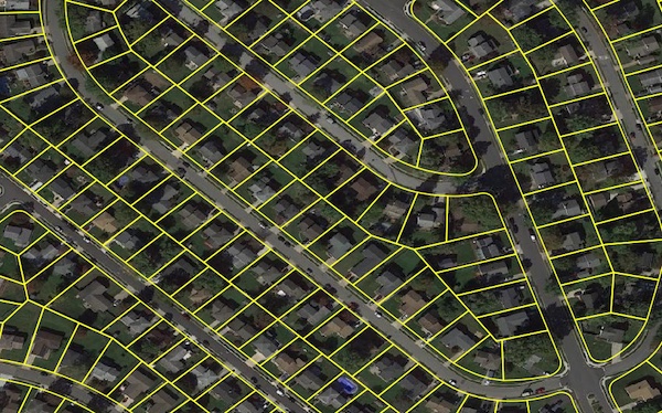
The Complete Overview of Property Parcel Boundaries
Property parcel boundaries are the legal demarcations that separate one landowner’s rights from another’s, encoded in deeds, surveys, and municipal records. Unlike physical markers (like fences or walls), these boundaries are defined by written descriptions—a combination of coordinates, distances, and references to fixed objects (e.g., "beginning at the northeast corner of the intersection of Maple Street and Oak Avenue"). These descriptions, often called metes-and-bounds, are the backbone of land ownership in common-law jurisdictions, including the U.S., Canada, and the UK.The complexity lies in how these boundaries are interpreted. A parcel’s shape may appear clear on a digital map, but in reality, it’s subject to surveying errors, historical revisions, and even natural erosion. For example, a boundary line described as "running due north for 50 feet" could shift if the original surveyor’s compass was misaligned or if the reference point (e.g., a tree) was removed. This is why property parcel boundary disputes are the second-most litigated issue in real estate, trailing only zoning violations. Understanding the interplay between cadastral maps (official land records), private surveys, and local ordinances is critical—whether you’re buying, selling, or defending your property rights.
Historical Background and Evolution
The concept of parcel boundaries traces back to ancient civilizations, where land was divided using natural features like rivers or stones. However, the modern property parcel boundary system emerged in medieval Europe, where feudal lords granted land in exchange for loyalty. These grants were documented in manorial rolls, the precursors to today’s deeds. The system evolved further during the Enlightenment, when surveying became a science. In 1785, the U.S. Land Ordinance established the rectangular (township and range) survey system, dividing public lands into 6-mile squares—still used in 30 states today.The 20th century introduced cadastral mapping, where governments began maintaining centralized records of parcel boundaries. This shift reduced fraud but created new challenges: older deeds often referenced natural monuments (e.g., "the oak tree at the corner"), which could disappear or move. Digital technology in the 1990s revolutionized property parcel boundary verification, with GPS and LiDAR enabling centimeter-level accuracy. Yet, even now, boundary disputes persist because many parcels still rely on 19th-century surveys or hand-drawn plats. The key takeaway? A boundary’s validity depends on its chain of title—the unbroken record of ownership—more than its age.
Core Mechanisms: How It Works
At its core, a property parcel boundary is defined by three elements: description, evidence, and enforcement. The description is the legal text in a deed (e.g., "beginning at the point where the north line of Lot 5 meets the east line of County Road 12"). The evidence includes surveys, plats, and deeds that prove the boundary’s location, while enforcement falls to courts, surveyors, and local assessors. When these elements conflict—say, a deed describes a boundary, but a survey shows it’s 10 feet off—the property parcel boundary complete guide principles come into play to resolve the ambiguity.Table of Contents
- The Complete Overview of Property Parcel Boundaries
- Historical Background and Evolution
- Core Mechanisms: How It Works
- Key Benefits and Crucial Impact
- Major Advantages
- Comparative Analysis
- Future Trends and Innovations
- Conclusion
- Comprehensive FAQs
- Q: How do I find my property’s recorded boundary lines?
- Q: What’s the difference between a boundary survey and a location survey?
- Q: Can a neighbor’s fence create a legal boundary?
- Q: What happens if my property’s boundary is disputed?
- Q: How often should I verify my property boundaries?
- Q: Are boundary disputes more common in certain types of properties?
- Q: Can I change my property’s legal boundary?
- Q: What’s the most common mistake people make with property boundaries?
The process begins with title examination, where an attorney or title company reviews the chain of deeds to identify inconsistencies. If a boundary is unclear, a licensed land surveyor is hired to perform a boundary survey, which may involve:
The surveyor’s report then becomes the evidence in court if a dispute arises. This is why property parcel boundary disputes often hinge on whether the surveyor followed ALTA/NSPS standards (the industry’s best practices).
Key Benefits and Crucial Impact
Property parcel boundaries aren’t just abstract legal concepts—they directly affect financial security, development potential, and even personal safety. For homeowners, an accurately defined boundary prevents encroachments (e.g., a neighbor’s deck built on your land) and ensures proper tax assessments. For investors, it determines zoning compliance and resale value; a parcel with a disputed boundary can lose 20% of its market value due to buyer hesitation. Even municipal services—like sewer hookups or road maintenance—depend on precise boundary records.The economic ripple effects are staggering. In 2022, the U.S. spent $1.2 billion resolving boundary-related lawsuits, with commercial properties facing higher risks due to complex easements and right-of-way issues. Yet, many owners overlook the property parcel boundary complete guide until a conflict arises. Proactive verification—such as ordering a title commitment or ALTA survey—can save thousands. As one real estate attorney noted:
"A boundary dispute isn’t just about land; it’s about control. Whoever holds the most accurate survey and the strongest chain of title wins—not just the dispute, but the leverage in negotiations." — James R. Carter, Partner at Carter & Associates Land Law
Major Advantages
Understanding and securing your property parcel boundaries offers five critical advantages:- Legal Protection: Clear boundaries prevent adverse possession claims, where a neighbor could gain title to your land if they’ve used it openly for 10+ years (varies by state).
- Financial Security: Accurate boundaries ensure correct property taxes, as assessors use square footage and land area from official records. A mismeasured parcel could lead to overpayment or underpayment penalties.
- Development Flexibility: If you plan to build, expand, or subdivide, zoning boards require certified boundary surveys to approve permits. A disputed line could delay projects for years.
- Insurance Coverage: Lenders and insurers often require ALTA/NSPS surveys for high-value properties. Without them, you may face denied claims if a boundary-related issue arises.
- Peace of Mind: Even if no disputes exist, verifying your boundaries with a recent survey (within 5 years) ensures future-proofing against climate shifts (e.g., coastal erosion) or municipal changes (e.g., road expansions).

Comparative Analysis
Not all property parcel boundary systems are equal. The method used—whether metes-and-bounds, rectangular survey, or lot-and-block—depends on location, history, and legal tradition. Below is a comparison of the three most common systems in the U.S.:| System | Description & Use Cases |
|---|---|
| Metes-and-Bounds | Uses distances (metes) and directions (bounds) to define parcels (e.g., "north 300 feet, then east 150 feet"). Common in the original 13 colonies and areas with irregular landforms. Pros: Highly flexible for unique shapes (e.g., waterfront properties). Cons: Prone to ambiguity if original monuments (e.g., trees) are gone. Requires surveyor interpretation for retracement. |
| Rectangular (Township & Range) | Divides land into 6-mile squares (townships), further split into 36 sections of 640 acres each. Used in 30 states (e.g., Midwest, West). Pros: Simple, grid-based, and easy to locate. Ideal for agricultural and rural land. Cons: No natural features—boundaries are purely mathematical. Errors in baseline/meridian calculations can cause disputes. |
| Lot-and-Block | Used in subdivisions and urban areas, referencing a plat map (e.g., "Lot 4, Block 2, Smith Subdivision"). Common in the South and West. Pros: Clear for residential developments; easy to verify with county records. Cons: Plat map errors (e.g., misaligned streets) can create gaps or overlaps. Requires subdivision approvals for changes. |
| Government Survey (Section, Township, Range) | A hybrid of rectangular and metes-and-bounds, used in public land states (e.g., Texas, Oklahoma). Combines grid references with natural features. Pros: Balances precision and adaptability. Cons: Complex for laypeople; disputes often arise over meander lines (shoreline boundaries). |
Future Trends and Innovations
The property parcel boundary complete guide is evolving alongside technology. Blockchain-based land records (piloted in Sweden and Georgia) promise to eliminate fraud by creating tamper-proof digital ledgers of ownership. Meanwhile, AI-powered survey analysis can cross-reference historical plats with LiDAR data to resolve ambiguities in seconds—a process that once took months. Drones and satellite imagery are also reducing survey costs by 60% for large parcels, though they raise new questions about data accuracy in dense urban areas.Another frontier is climate-adaptive boundaries. As sea levels rise, coastal properties face retreat lines—legal boundaries that move inland to account for erosion. Florida and Louisiana are already testing dynamic boundary systems, where parcels are redefined based on predictive modeling. For rural landowners, precision agriculture tech (e.g., GPS-guided tractors) is forcing a rethink of easement and right-of-way boundaries to avoid crop damage. The future of property parcel boundaries won’t just be about lines on a map—it’ll be about adaptive, data-driven ownership.
Conclusion
Property parcel boundaries are the silent guardians of real estate value, yet their importance is often overlooked until a crisis strikes. Whether you’re inheriting a rural farm, investing in urban real estate, or simply defending your backyard, the property parcel boundary complete guide principles—description, evidence, and enforcement—are your first line of defense. The cost of ignorance is steep: disputed boundaries can derail sales, inflate legal fees, and even invalidate insurance claims.The good news? Technology and legal frameworks are making boundaries more transparent than ever. From ALTA surveys to blockchain deeds, the tools to secure your property exist. The question is whether you’ll act before a neighbor’s fence—or a surveyor’s report—redefines your land.
Comprehensive FAQs
Q: How do I find my property’s recorded boundary lines?
A: Start with your deed, which contains the legal description. Then, visit your county recorder’s office or use an online parcel viewer (most counties offer this). For precise lines, order an ALTA/NSPS survey from a licensed land surveyor. If your property is in a subdivision, check the plat map on file with the county.
Q: What’s the difference between a boundary survey and a location survey?
A: A boundary survey determines where your property lines are (and whose they belong to), often resolving disputes. A location survey (or site plan) shows improvements (e.g., house, fence, driveway) relative to the boundary but doesn’t define the line itself. If you’re building, you’ll need both—the boundary survey to avoid encroachments, and the location survey for permits.
Q: Can a neighbor’s fence create a legal boundary?
A: Not automatically. A fence may establish a boundary if:
1. It’s built with mutual agreement (written or implied).
2. The landowner acknowledges it in a deed or survey.
3. The fence has been in place for years (potentially triggering adverse possession laws, which vary by state).
Without proof, a fence is just a structure—not a legal line. Always confirm with a survey before assuming.
Q: What happens if my property’s boundary is disputed?
A: Disputes are resolved through court action, mediation, or surveyor agreement. Steps to take:
1. Hire a licensed land surveyor to perform a boundary retracement survey.
2. Review historical records (deeds, plats, old surveys) for clues.
3. Negotiate with the neighbor—some disputes are settled via compromise lines or monetary agreements.
4. If unresolved, file a quiet title action in court, where a judge will rule based on evidence (surveys, deeds) and legal principles (e.g., equitable estoppel).
Q: How often should I verify my property boundaries?
A: Before major transactions (buying/selling), after natural disasters (floods, landslides), or if you suspect encroachments. For most owners, a one-time ALTA survey (cost: $800–$2,500) is sufficient unless you’re in a high-risk area (e.g., coastal, mountainous). Rural properties may need checks every 5–10 years due to erosion or shifting waterways.
Q: Are boundary disputes more common in certain types of properties?
A: Yes. Waterfront properties (lakes, rivers, oceans) have the highest dispute rates due to shoreline changes. Subdivisions also see conflicts over shared driveways or HOA boundaries. Agricultural land disputes often involve fence lines and easements, while urban properties may face issues with setback violations or undocumented additions (e.g., a neighbor’s shed). Commercial properties are riskier due to complex easements and right-of-way agreements.
Q: Can I change my property’s legal boundary?
A: Only through legal processes:
Q: What’s the most common mistake people make with property boundaries?
A: Assuming the fence is the boundary. Other top mistakes:
1. Ignoring the deed’s legal description—many owners never read it.
2. Assuming old surveys are accurate—technology and land changes make them obsolete.
3. DIY boundary resolution—attempting to negotiate without a surveyor or attorney often worsens disputes.
4. Overlooking easements—a neighbor’s right to cross your land can limit use, even if the boundary is clear.
5. Not updating records—if you build a new fence or wall, register it with the county to avoid future disputes.
Leave a Comment
Comments are moderated before appearing. The data you submit is processed according to the Privacy Policy of Viralcontentbee.